
 |
 |
|
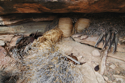
In August 1919, George K. Davol led a crew of men into Grand Cayon to survey a route for a transcanyon aerial tramway. If built, the tramway would have connected the south and north rims via several way stations, including one at Tower of Set. Davol undertook the survey with the backing of the Santa Fe Railway and the approval of Horace Albright, who was Stepen Mather's top assistant at the National Park Service. Between August and November 1919, Davol's team mapped and surveyed a route for the tramway. They also built lightweight supply trams to deliver materials to the camps established along the route. When they left Grand Canyon at the end of the year, Davol and his crew cached materials that would be needed when work continued the following year. However, the aerial tramway concept fell out of favor with Mather. Having lost the support of the dynamic leader of the National Park Service, the project was shelved and the material cache was soon forgotten.
So it was that ninety years later, Dennis Foster and I were exploring the Tonto plateau below Tower of Set in search of evidence of the 1919 survey. Dennis had added this day hike to an itinerary that included, as the primary objective, closing the last remaining gap in his route north of the Colorado River from Nankoweap to Kanab Creek. The remaining section was a route from Phantom Ranch to the drainage leading down to the Colorado River upstream of Ninetyfour Mile Rapids. Dennis had intended to fill this in during our March 2009 hike from Crazy Jug to Phantom Ranch. However on the eighth day of the hike, he had injured his left foot and was in no condition to hike the rough terrain that lay between us and Phantom Ranch. So, we used Chris Forsyth's SPOT device to signal a rescue. Within two hours, a helicopter flew in from the South Rim. Dennis was examined and evacuated, leaving Chris, John Eastwood and I to finish the trip.
Fast forward eight months to November 25. It was Thanksgiving week but Dennis and I would not be celebrating the holiday with family. We would have our feast in Grand Canyon. A chill and cutting winds buffeted us all morning along the South Kaibab Trail. Normally, I'm most comfortable hiking in a short sleeve T-shirt but on this day I kept my sweater on all the way to Bright Angel Campground. There weren't many hikers on the trail with us. Several people who'd shared the express bus ride from the Bright Angel Lodge to the South Kaibab Trailhead joined us on the trail. We passed two hikers on their way out of the canyon just above Ooh Ahh Point and another group of college-aged Europeans in the switchbacks above the Black Bridge. But for the most part, Dennis and I had the trail to ourselves. This wasn't surprising considering that the next day was Thanksgiving. Most folks, even Grand Canyon hiking enthusiasts, were home with family and friends.
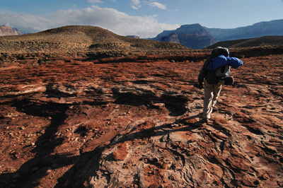
After lunch at the picnic table in the northern-most campsite, we cached our meals for the last night and began the steep, crumbly ascent along the route that leads from Bright Angel Campground to Utah Flats. Dennis was fighting a bad cold and I was finally over the cold that had sidelined me a couple of weeks before. I had been through Piano Alley during the March 2009 hike, but that was heading down into Phantom Ranch and the route did not look familiar as we ascended through the Tapeats. We found a stairstep exit along the left (south) side of the alley and emerged to the open shallow just below Utah Flats. We stopped to check on a water cache Dennis had placed, earlier in the year, and continued on to Utah Flats. It was 3:20 pm when we left the water cache, which gave us about two hours of daylight to reach our destination for the night, Phantom Creek.
We made good time through Utah Flats and up the route along the west side of Phantom Creek Canyon. Cheops Pyramid hovered over us like a mighty castle. Shortly after 5:00 pm, we stopped at the junction with the route into Phantom to cache our food for the majority of the hike. We would spend only one nigth in Phantom Creek and would pass by the cache the following day en route to the Cheops-Isis saddle. There was no need to pack in the food supplies when we would just be packing them out in another fourteen hours. Twilight deepened as we followed the route into Phantom. Although this was my first time on the route, it was well-defined and easy to follow, even in the darkening afternoon conditions. We reached Phantom Creek about 5:45 pm and quickly found a great campsite on the east side of the creek.
The next day was November 26, Thanksgiving. We got a very late start from Phantom Creek, not waking up until nearly 7:40 am and not leaving camp until about 10:15 am. Soon after leaving our perfect spot in Phantom Creek, we stopped so I could address a leaky water bladder. That annoyance dealt with, we continued the hot and sweaty ascent to our food cache. We had filtered and were carrying much more water than we'd packed into Phantom Creek. And even though There was a water cache awaiting us at the Cheops-Isis saddle, we needed all we could carry because Trinity Creek, which is where we would be camped for three days on this trip, has no reliable springs. I carried six liters of water from Phantom Creek and felt every one of those 13 pounds.
We reached the food cache at 11:10 am and reloaded our packs adding even more weight. "My pack keeps getting heavier," would be a common refrain on this hike. It was just after Noon when we arrived at the Cheops-Isis saddle and took a rest break to retrieve some of the water cache. We each added 1.5 liters of water, leaving another two liters for our return on the coming Sunday. Leavign the saddle, my pack was heavier by another 3.3 pounds. As I said, this was getting to be a common theme. We hiked another forty-five minutes until stopping for lunch. We chose a spot in the lea of a huge boulder on the plateau west of the Cheops-Isis saddle. After lunch, we continued hiking west, first through the large bay on the south side of Isis Temple and then around the southern arm of the bay to a vantage point that offered our first view into Trinity Creek Canyon. The time was 2:25 pm.
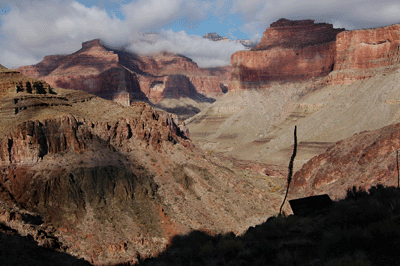
Soon after, we spotted a set of cairns marking the top of the descent route into Trinity. This route led into the upper end of the northeast arm and, at 3:16 pm, we set foot in the bed of Trinity Creek. Forty-five minutes of boulder hopping took us to a clean and flat area opposite a minor drainage. We dropped our packs. This would be base camp for the next couple of days. Dennis found a deer antler resting atop a boulder and, from that moment on, this site would be known as Antler Camp. Although we had plenty of water for the night and next day, we wanted to scout the area for any water sources. Hiking downstream to the junction with the main arm of Trinity Creek, we headed upstream from there and quickly found two very smelly water pockets. Their unappealing nature earned these "emergency water sources" the nicknames, skank I and skank II.
Continuing upstream turned up two more water pockets, one of which actually looked reasonably clean. We discussed our optoins on the way back to Antler Camp and agreed that it would be best to reserve the Trinity Creek pothole water for emergencies. We knew we would find good water at the Colorado River, which was running green and clear. We would hike to Ninetyfour Mile Rapids in the morning for water and, along the way, Dennis would complete his route north of the river from Nankoweap to Kanab Creek. With that settled, we set up camp and prepared a Thanksgiving feast. I brought a dehydrated meal of chicken with mashed potatoes. Dennis added stuffing, gravy, cranberry flavored apple sauce and a three-berry cobbler. It was a genuine Thanksgiving feast and, afterward, I could not recall feeling so full after a backpacking meal.
I was admittedly skeptical of our ambitious day hike agenda for the following day, November 27. We would hike from Antler Camp to the Colorado River just above Ninetyfour Mile Rapids, filter water and return to Trinity. The round-trip distance would be about ten miles, which was not outrageous by our standards. The challenge would be to complete the trek before dark. We planned to be on the trail by 7:00 am when there would be enough light for the ascent from Trinity Creek Canyon to the Tonto. That would give us approximately ten and a half hours of daylight to complete the hike. Following the descent route back into Trinity in the dark was not an appealing option.
Of course, we got a late start. We were up at 6:00 am for breakfast but did not leave Antler Camp until 7:45 am. Nine hours, forty-five minutes of daylight remained. We made good time to the exit route from Trinity. This is a cairned route about 200 meters upstream of the junction of the main and northeast arms of the canyon. The exit route was mostly in the sun and fairly easy to follow. There were several cairns marking the way and we added a couple just to erase any doubt on our return trip. We rimmed out on the Tonto plateau along the eastern slopes below Tower of Set shortly after 8:00 am. Fifteen minutes later, Dennis realized we should be able to see up the northeast arm of Trinity from our vantage point on the Tonto. Sure enough, both our tents stood out against the rocky creek bed. Nine hours and change of daylight remained.
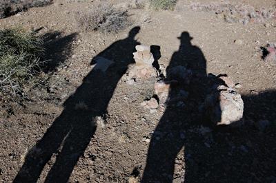
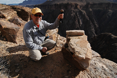
We had packed lightly for this trek, carrying our full compliment of water storage containers, lunch, snacks and some emergency supplies. Making good time across the Tonto, we rounded the tip of the south-pointing arm below Tower of Set at 9:30 am. From there, we could see across the unnamed bay to the west and picked out the boulder strewn knob where Dennis had been evacuated from the canyon during the Crazy Jug hike. The hike around the bay below Set was tedious and slow in stretches. But at 10:35 am, we arrived at the extraction point. It was a moment of celebration. Not only had Dennis completed the hike he had led in March, he had filled in the last open section of a route north of the Colorado River from Nankoweap to Kanab Creek. We erected a small cairn to mark the ocassion and the spot, took some photos and continued with the hike. It was 10:35 am and less than seven hours of daylight remained.
The descent through the drainage to the river was slow and hot work. We kept mostly along the right (west) side of the drainage as that seemed to offer the easiest path. We stopped at the base of the Tapeats to check out some ruins. After a short break, we continued down through the boulder-choked slot and arrived at the river at 12:10 pm. My lunch on this day was not different than my lunch on any other day of this hike: dry salami and mild cheddar on an everything bagel with mayonaise. I also ate the mini Hershey chocolate bar with almonds that I'd skipped after the previous night's feast. Then, it was time to filter water. We would need enough to last the rest of the day, the following day and next morning until we would reach the water cache at Cheops-Isis saddle. When it was all said and done, I packed eleven liters of water from the river. My pack weight had increased by twenty-four pounds. "My pack keeps getting heavier."
It was 1:10 pm when we left our sandy beach alongside the Colorado. Four hours, twenty minutes of daylight remained for the return hike to Antler Camp. The climb up through the drainage to the Tonto plateau was grueling and hot work. The extra water weighed us both down but, for some reason, we also made better time than when we'd hiked down the drainage. We made a short stop at the ruins. Staying strictly to our left (west) from there, we arrived at the top of the drainage less than fifteen minutes after leaving the ruins. We continued to the extraction point and, after a short break, left that landmark location at 3:05 pm. We had about two and a half hours of daylight.
It was time to put our heads down and make some time. We tightened our packs, focussed on the route and didn't stop until we arrived at the saddle below Tower of Set from which we could see into Trinity. It was 4:15 pm with just over an hour of daylight remaining. Neither of us wanted to make the descent into Trinity in the dark. It is not a difficult route but, in the dark, it becomes too easy to miss a cairn, turn an ankle or worse. We arrived at the top of the descent at 5:10 pm and were in the Trinity Creek bed at 5:38 pm. Dusk was heavy and it would be fully dark within ten or fifteen minutes. But the hardest part of the hike was done. We had kicked some Tonot butt on this day.
Later that night at camp, we discussed our options for the following day. Before the hike, we had talked about heading up Trinity to the Isis-Sheva saddle. But this was of secondary interest to the search for the 1919 aerial tramway survey campsites. While hiking through the large bay along the south side of Tower of Set, we'd inspected from a distance the route through the Redwall up to Set. This had looked fairly challenging. However while hiking below the arm extending east from Tower of Set on our way back to Trinity, Dennis has spotted a low plateau which he suspected as one of the sites used by Davol's team. And so it was decided that the next day, November 28, we would return to this area to look for evidence of the 1919 aerial tramway survey.
The suspect plateau was a short hike from camp so, we got a late start that morning. It was just after 9:30 am when we left Antler camp in Trinity Creek and, by 10:20 am, had topped out on the Tonto. The weather was partly cloudy and mildly threatening of rain throughout the day. In other words, conditions were perfect for a late November hike in Grand Canyon. We worked our way south along the west rim of Trinity. Overhead, a hawk slowly circled in search of a rodent or other mid-morning snack. Our pace was as casual as the hawk's, with only a short distance to hike and all morning to get there.
We reached the plateau just before noon. Dennis had brought some prints of photos taken during the 1919 survey and it only required a few minutes to match two photos with vantage points on the plateau. With the number of men on the survey team and the length of their stay in the canyon, we had hoped to find ample evidence of their presence in the form of trash and left over materials. However, after more than thirty minutes of slowly and methodically walking the plateau, the sum total of our findings were a rusted washer, an old cotter pin, a nail and a pottery sherd. These items--with the exception of the sherd--confirmed the survey team's presence on this site but was, nonetheless, not the impressive cache we had hoped to find. The 1919 crew had done an admirable job of packing out their trash.
We ate lunch on the plateau. During the break, I used my mini-binoculars to scan the Tonto plateau on the south side of the river. Long sections of Tonto trail between Monument and Horn Creek were visible and I soon picked up a group of five hikers. The time was 12:40 pm, and the group was below and to the west of Dana Butte. They were hiking east toward Horn Creek. One member of the party appeared to be wearing a red or orange backpack.
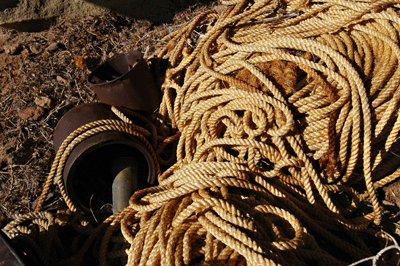
After lunch, Dennis and I hiked over to the rim overlooking the Colorado. One of the maps produced by the 1919 survey showed a lightweight supply tram on the rim and just downstream of the point overlooking Trinity Creek's opening into the river. Among the archival photos Dennis had packed, were two taken from this area and we were able to use these images to identify the location where the supply tram had been constructed. And it was here that we found a large cache of materials left behind by the survey. The materials included large coils of rope, buckets filled with bolts, screws and other hardware, and an accordian gate that may have been left to protect the cache. We also found large blocks of stone that had been used to anchor the supply tram. The abundance of material suggested that few people had visited this site since the survey team's departure in November 1919.
This was the kind of find that keeps me coming back to Grand Canyon. The canyon is a beautiful place, to be sure. Her beauty is enough to leave a man speechless. But it is the human connection to Grand Canyon that makes this place special to me. That connection is palpable, if one only knows where to look. Whether finding ancient Indian ruins, an old cowboy camp or a supply cache from an early 20th Century expedition, these are the experiences that draw me back, time and again. These are the finds that connect me to this place that has been central to the lives of so many people over the centuries.
Hiking back to camp, Dennis and I discussed the possibility that we were among the very few who had visited the rim site in the last ninety years. This is not a site other hikers discuss and has gone almost unmentioned in books about the Grand Canyon. Neither Harvey Butchart nor George Steck mention the materials we found at the rim overlooking the river. Jim Ohlman has researched the 1919 survey and gave a presentation on this subject at the 2002 "A Gathering of Grand Canyon Historians." It was Ohlman's presentation and archival photos available on the Web that Dennis relied on to prepare for our day hike. Finally, the abundance of material that remains suggests the site has not received much attention. Typically, then number of artifacts found at a site are inversely proportional to the number of visitors the site has received.
That night, our last at Antler Camp, the clouds finally delivered on their threat of rain. It came sporadically in gentle waves. Beginning with the tips and taps of solitary drops against the rain fly, the symphony built slowly until a constant soft hum of drops pattered against the nylon shell. Then, after a few minutes, the symphony would slow with individual drops becoming discernible until the silence of the night finally emerged.
It was still raining the following morning. On November 29, the fifth day of our hike, Dennis and I made the return trek to Phantom Ranch. Our permit included a night at Bright Angel Campground before hiking out on the Bright Angel Trail the following day. We hiked from Trinity Creek to the Cheops-Isis saddle in the rain. I think the rain made it easier to follow game tracks and routes. We used the south extending drainage to make our exit from Trinity. This was the drainage we used in March, too. After a short break beneath a Tapeats overhang, we went up a minor drainage to our left which led up to the Tonto. Once out in the open, we headed for a small hill and then for a debris ramp that looked like it would lead to our exit route up from the Tonto.
Dennis and I switchbacked fairly high up the debris ramp before stopping to scout the way ahead. We both saw a line angling up to the shelves above and decided to continue farther up the ramp to see if would cross the route. Sure enough, we encountered a couple of cairns and a trail of use, which led up onto the shelves. I took the lead and managed to stay on this route all the way to and through the large bay south of Isis Temple. The route became very faint as we hiked across the plateau to the west of the saddle. So, I stayed on a line that maintained a constant elevation and, after about a quarter mile, picked up another cairned route that led up to the saddle.
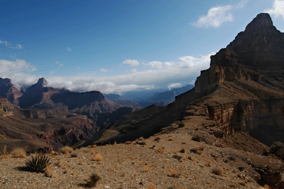
Just below the Cheops-Isis saddle, we stopped beneath a sheltering overhang for lunch. The skies began clearing in earnest during this respite. The rain stopped, altogether, but was replaced by a chill breeze. Still, it was nice to feel the sun and to start drying. The time was 1:08 pm when we reached the junction with the route into Phantom Creek. Fifty minutes of hiking at a steady pace brought us to the cactus field overlooking Utah Flats. Now, the sun was shining with full force and the wind had calmed considerably. I stopped to shed my rain gear and sweater, and would spend the remainder of this day hiking in short sleeves.
After a brief delay to bandage an agave puncture wound in my left calf, we continued our trek. At 2:30 pm, we arrived at the head of Piano Alley. We reached the bottom less than thirty minutes later at 2:58 pm. It was 3:32 pm when we set foot in Bright Angel Campground. We selected a campsite and dropped our packs. Given the number of open spots, we figured there was an outside chance at getting last-minute seats at tonight's dinner in the Phantom Ranch Canteen. So, it was off to the Canteen for cocoa. We were right, there were two seats available for the hiker's stew supper at 6:30 pm. We had only a few minutes to drink our hot cocoa and write post cards, before the Canteen closed to prepare for dinner. On the way back to camp, I decided to sit in on the 4:00 pm ranger talk. It was a game of Grand Canyon Jeopardy and I knew the questions to most of the answers.
Later that night, I devoured two full bowls of stew. After four nights of dehydrated backpacking meals, the beet, potatoes, corn and carrot stew really hit the spot. The meal was accompanied by salad, cornbread and coffee. Dessert was a large slice of chocolate cake. After dinner, we attended the 7:30 pm ranger talk about the history of exploration of the Colorado River. Ranger Mandy gave an entertaining talk. Our night concluded back at the Canteen where we savored Lemmies and chatted with another hiker who was staying in the dorm with his son-in-law.
The following morning, Dennis and I awoke at 5:00 am for the early breakfast. It was dark and chill as we made the trek to the Canteen. But it was worth it. There's nothing like a large breakfast to fuel a day on the trail. We at pancakes, eggs, bacon and fruit chased by cups of steaming hot coffee. Then, it was back to camp to pack. It was still dark and still chill when we left the Canteen, but twilight would begin the task of peeling away the night, soon enough. Packing went casually and carefully. We had plenty of time to make sure everything was properly squared away before it would be brigth enough to leave camp.
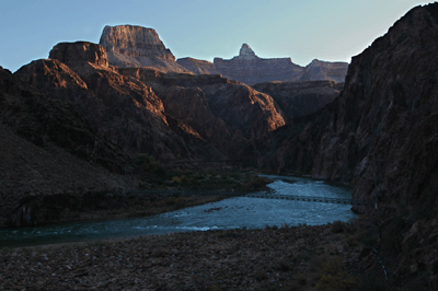
Our boots hit the trail south out of Bright Angel Campground at 7:40 am. It was actually pretty warm, warmer than it would be at the South Rim that day. Leaving the campground, we continued west to the Silver Bridge which would take us across the Colorado. Once across the river, we followed the river trail west to pick up the Bright Angel Trail. I was feeling particularly strong that morning and set a pace that would allow me to reach Indian Garden at 9:50 am. While snacking at IG, I used the mini-binoculars to watch as a helicopter removed a car from just below the South Rim. The car had been driven off the rim earlier in the year in a successful suicide attempt. What a waste.
Leaving Indian Garden at 10:00 am, I set and maintained a steady pace up the trail. Recent trail work had the Bright Angel in excellent condition. The clouds and cool air made for perfect weather conditions to attempt a personal best hiking time to the rim. I passed by the Three Mile Resthouse at 10:41 am. The Mile and a Half Resthouse was accomplished at 11:21 am. I took a five-minute break before continuing with the hike. Soon after leaving the last resthouse, a crisp breeze forced me to stop and don the sweater. I'd been hiking in short sleeves all morning until that point. Finally, I arrived at the Bright Angel Trailhead at 12:10 pm, just four and a half hours after leaving Bright Angel Campground.
I bought a cup of hot cocoa from the Bright Angel tavern and retired to a bench in the sun to savor the hot drink. The sun felt good and I enjoyed hearing the excitement in the voices of canyon visitors. I spent a relaxing hour and a half on that bench soaking in the warmth of the day and the place. Walking to the trailhead parking lot, I found Dennis in the midst of changing into fresh clothes. I joined him and, comfortably out of our hiking clothes, we made the short walk to the Bright Angel Lodge for lunch. I had a bread bowl of the hiker's chili. Afterward, we stopped at the Kolb Studio before starting the long drive home to Flagstaff. We had been out of the canyon just a couple of hours and, already, our hike was starting to seen a distant memory.
 |
 |
 |