 |
 |
|

Nearly 5 million people visit Grand Canyon each year. Of those, about 150,000 (3%) will venture below the rim. For those who do take the time to explore below the rim, one of the most popular routes is South Kaibab trail. At 6.3 miles in length, South Kaibab is the shortest rim-to-river trail in the park. Most day hikers opt to stop short of the river, targeting Ooh Ahh Point and Cedar Ridge as destinations.
The 1 1/2 mile roundtrip to Ooh Ahh Point is a great introduction to Grand Canyon hiking. The views along the upper portion of South Kaibab are truly stunning, the return trip gives you a taste of hiking up a Grand Canyon switchback and, should you get into trouble, you're never too far from the rim and help. These were just a few of the reasons I chose this hike for my innaugural excursion below the rim of Grand Canyon. On September 18, 2006, I had a day off from work and decided to make the 90 minute drive to the South Rim for a short hike down the South Kaibab to Ooh Ahh Point.
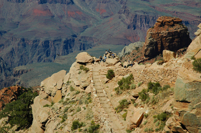
Private vehicles aren't allowed at the trailhead parking area, much of the year, so I parked at a picnic area along the South Rim drive and hiked about 1/2 mile to the trailhead. By 1:15 pm, I was heading down the South Kaibab. The trail begins with a series of switchbacks that quickly take you through the gray Kaibab limestone. Spectacular views of the canyon are available along the entire trail. The vertical face of the Redwall and, at its base, the Tonto platform are fairly prominent features throughout the eastern canyon. The narrow granite gorge of the Colorado River winds through the heart of this corridor area.
As mentioned above, my destination on this short hike was Ooh Ahh Point where the trail suddenly emerges from the shadow of Yaqui point to present jaw-dropping views of Grand Canyon. A group of hikers were resting there and savoring the view as I approached. It was an impromptu international gathering; one group from Georgia, a couple from Germany, another couple from France and one guy from Flagstaff. Later, we were joined by two college-aged hikers from Japan. The young man didn't expect to find me sitting behind a boulder munching a granola bar and taking in the view.

From Ooh Ahh Point, the South Kaibab descends to Cedar Ridge. The shade trees and restroom facilities combine to make Cedar Ridge a popular rest stop. From here, the trail skirts the eastern flank of O'Neill Butte until reaching Skeleton Point. The descent from Skeleton Point to the Tonto is long and steep. The phrase, "knee-jarring," comes to mind as an apt description. Following the descent from Skeleton Point, the South Kaibab intersects with the east-west running Tonto trail. There, you'll find the second rest area with restroom facilities along the trail. From an overlook appropriately dubbed The Tipoff, the South Kaibab begins its plunge through the Tapeats to the Colorado River. Emerging from the tunnel blasted through the Vishnu Schist, the trail arrives at the Black Bridge and crosses the Colorado.
After enjoying a snack and water break at Ooh Ahh Point, I packed up my gear and began the hike back to the rim. Along the way, I met a group of hikers who were finishing a rim-to-rim hike. They had left the North Rim at 8:00 am, followed the North Kaibab Trail through Phantom Ranch to the Colorado and taken the South Kaibab trail from the river to the South Rim. They hiked about 21 miles, if my math is correct, over the course of about 7 1/2 hours. My short foray ended about 3:30 pm or a bit more than 2 hours after beginning the hike.
In a manner of speaking, today's hike was a dip of my toe into an unknown--to me--sea called, Grand Canyon. How long until I find myself fully immersed in this amazing place? Time will tell.
Bill Ferris
Flagstaff, Arizona
 |
 |
 |